
Smart Mapping of Urban Homelessness and Informal Settlements
India’s urban growth story is both inspiring and complex. While cities continue to drive economic progress, they also face widening disparities in access to housing and essential services. Amid the rapid expansion of metros and smart cities, millions of people live without secure shelter, basic sanitation, or legal recognition. The issue of urban homelessness and informal settlements is not just a planning challenge; it reflects deeper questions of social equity, governance, and the right to live with dignity. In recent years, geospatial technologies have emerged as powerful tools that enable policymakers to understand these issues with clarity, accuracy, and empathy.
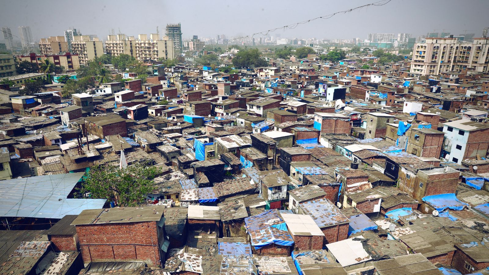
Understanding the Challenge
According to the Census of India 2011, around 1.77 million people were homeless and more than 65 million lived in slums. These figures are expected to have grown as urbanisation has intensified. Migration from rural areas, coupled with the rising cost of land and limited affordable housing, has led to the expansion of informal settlements across many cities. These communities often develop in peripheral or hazard-prone areas, exposing residents to risks of eviction, flooding, and inadequate infrastructure. Traditional surveys and paper records struggle to capture the dynamic nature of such settlements, where populations shift seasonally and new clusters appear frequently.
This is where geospatial mapping transforms the approach. Using Geographic Information Systems (GIS), remote sensing, and Unmanned Aerial Vehicles (UAVs), authorities can create real-time spatial databases that accurately represent the extent, density, and living conditions of informal areas. Such maps become essential for targeted housing policies and inclusive urban planning.
The Role of Geospatial Technologies in Housing Missions
India’s flagship urban housing schemes, the Pradhan Mantri Awas Yojana – Urban (PMAY-U) and the Deendayal Antyodaya Yojana – National Urban Livelihoods Mission (DAY-NULM), have increasingly relied on geospatial intelligence for planning and monitoring.
PMAY-U, launched in 2015, uses GIS to identify slum clusters, assess land availability, and plan in-situ redevelopment projects. By integrating spatial data with demographic and infrastructure layers, local bodies can determine where to construct affordable housing and how to ensure optimal land use. The Ministry of Housing and Urban Affairs has also partnered with the Indian Space Research Organisation’s Bhuvan platform to track progress spatially, ensuring transparency and accountability.
Under DAY-NULM, which focuses on improving the livelihoods and shelter of the urban poor, GIS mapping supports the identification and management of night shelters. With GIS-enabled dashboards, authorities can monitor occupancy, accessibility, and service delivery, helping ensure that shelter facilities meet demand and remain equitably distributed across urban areas.
Emerging Technologies for Smarter Mapping
Recent technological advances have made mapping even more precise and inclusive. UAV or drone-based surveys allow for high-resolution imaging of dense informal settlements, producing accurate base maps that guide infrastructure planning. Drones can capture roof patterns, road access, drainage layouts, and open spaces within settlements, enabling better assessment of upgradation needs.
Mobile GIS applications have also changed how urban data is collected. Field enumerators can now record information on residents, housing types, and facilities directly through GPS-enabled devices, linking it to precise locations. This approach ensures that no household is left unrecorded and that the data remains current. Combined with spatial poverty mapping, where economic indicators are analysed alongside spatial data, these tools allow planners to visualise concentrations of poverty, service deficits, and environmental risks, creating a more holistic view of urban vulnerability.
Case Study: Tamil Nadu Urban Habitat Development Board
Tamil Nadu provides one of the best examples of how GIS can transform housing governance. The Tamil Nadu Urban Habitat Development Board (TNUHDB), formerly the Slum Clearance Board, has been using GIS to identify and manage informal settlements and homeless populations. The board, in collaboration with local bodies, has developed a comprehensive spatial database integrating satellite imagery and field surveys.
This database helps classify settlements based on legal status, population density, and access to services, making it easier to prioritise areas for in-situ redevelopment or resettlement. The same spatial framework is used to plan night shelters and rental housing for the urban homeless. TNUHDB’s approach exemplifies how a combination of technology and data-driven policy can ensure that state housing missions reach the most marginalised groups efficiently.
Urban Applications: Delhi and Indore
Several cities are already applying geospatial intelligence to bridge social and spatial inequalities. In Delhi, the Delhi Urban Shelter Improvement Board (DUSIB) manages a city-wide network of night shelters. Using GIS, DUSIB monitors the location, capacity, and utilisation of these shelters in real time. During extreme heat or cold, this system enables rapid deployment of resources and helps ensure that vulnerable populations receive timely support.
Indore, one of India’s leading Smart Cities, has extended its geospatial initiatives from sanitation and waste management to informal housing. Through drone surveys and GIS analysis, the city has mapped slums and overlaid them with data on roads, drainage, and sanitation coverage. This has helped prioritise areas for infrastructure improvement and integrate informal settlements into the city’s formal master plan. Such examples show how spatial intelligence can promote both efficiency and inclusion.
Overcoming Persistent Challenges
Mapping homelessness and informal housing is inherently complex. Populations are mobile, data becomes outdated quickly, and many residents lack formal identification or land tenure documents. To overcome these challenges, mapping exercises must be continuous and participatory. Engaging communities during data collection not only improves accuracy but also fosters trust and ownership.
Seasonal migration adds another layer of difficulty, as occupancy in informal settlements fluctuates throughout the year. Authorities need systems that update data dynamically through remote sensing, AI-based change detection, and mobile surveys. Ethical considerations are equally vital. Since mapping involves sensitive personal information, strong data-protection mechanisms must ensure privacy and prevent misuse.
Towards Data-Driven Urban Inclusion
The future of geospatial mapping in housing lies in its integration with emerging technologies such as artificial intelligence and the Internet of Things. AI algorithms can analyse high-resolution imagery to automatically identify informal structures and predict areas of potential settlement expansion. IoT-based sensors can monitor living conditions, environmental quality, and infrastructure usage in real time. Together, these technologies can help cities adopt a preventive approach—addressing vulnerabilities before they become crises.
Collaboration between public agencies, academic institutions, and the geospatial industry will be key to sustaining these efforts. Shared spatial data infrastructures, open-data policies, and capacity building for local authorities can ensure that geospatial innovation becomes a regular part of urban governance. When combined with community engagement and strong institutional frameworks, mapping can become a foundation for equitable city planning.
Conclusion
Smart mapping of urban homelessness and informal settlements marks a shift from reactive welfare to proactive inclusion. By revealing patterns of inequality and vulnerability that were once invisible, geospatial technologies are helping policymakers design more responsive and humane urban interventions. Every spatial layer represents more than data; it tells a story of people, their resilience, and their right to a dignified life.
Through initiatives under PMAY-U, DAY-NULM, and forward-thinking models like TNUHDB, India is demonstrating how geospatial intelligence can guide cities toward greater inclusivity. As the nation advances toward its vision of Housing for All, smart mapping will remain central to ensuring that urban growth benefits every citizen. With technology as the enabler and compassion as the guiding principle, India’s cities can become not only smarter but also more just and humane.


Leave a Comment