
Urban Digital Twins for Smart Cities 2.0
Across India, urban centres are confronting unprecedented challenges due to rapid population growth, climate variability, and complex infrastructure demands. Traditional planning and management systems are being stretched to their limits, prompting policymakers and city administrators to explore tools that can provide real‑time insights, predictive analytics, and integrated planning capabilities. In this context, urban digital twins have emerged as a transformative urban data infrastructure that enables cities to visualise, simulate, and optimise complex urban systems in a dynamic virtual environment.
Urban digital twins are three‑dimensional, real‑time digital replicas of physical city environments. They merge spatial data with live inputs from sensors, cameras, and administrative systems to create a single platform where planners can assess current conditions, simulate future scenarios, and make data‑driven decisions. As India transitions into Smart Cities Mission 2.0, digital twins are becoming central to the strategy for building resilient, efficient, and sustainable urban futures.
Digital Twins: Concept and Technology
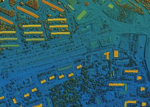
At its core, a digital twin is not a static map but a living model that integrates multiple technologies to mirror real‑world city behaviour. High‑resolution three‑dimensional mapping is made possible through Light Detection and Ranging (LiDAR) — a remote sensing technology that captures accurate spatial details of urban features such as buildings, roads, and terrain. These geometric datasets form the structural foundation of the twin.
Spatial intelligence is further enriched through Building Information Modeling (BIM), which brings semantic depth to infrastructure assets by documenting attributes related to construction, condition, usage, and lifecycle stages. When BIM is integrated with Geographic Information Systems (GIS), it enables planners to understand not only where things are, but what they are and how they perform.
Real‑time data from Internet of Things (IoT) sensors and connected devices provides dynamic updates to the digital twin. Data streams on traffic flows, water levels, environmental quality, energy usage, and public transport operations keep the twin in sync with the physical city. Cloud computing and modern analytical engines ensure that large volumes of geospatial and temporal data are processed efficiently, supporting real‑time visualisation and simulation. Artificial intelligence and machine learning further augment analytical capabilities, enabling predictive modelling that can forecast outcomes based on proposed interventions.
Together, these technologies allow urban digital twins to evolve beyond visual representations into platforms that support operational decisions, long‑term planning, and crisis management.
India’s Adoption: Real‑World Implementations and Pilots
India has moved from conceptual interest in digital twins to real operational implementations in several cities, demonstrating their utility for urban development challenges.
In Varanasi, one of the earliest and most advanced digital twin deployments in India was completed through multimodal LiDAR surveys across 160 square kilometres of city area. This three‑dimensional spatial model captures fine details of built and natural environments using airborne, drone, and vehicle‑mounted sensors. It has been integrated with live surveillance camera feeds to support traffic management, crowd monitoring, flood risk assessment, and infrastructure planning. The project was recognised with a national Smart City Innovation Award in 2025, reflecting its pioneering role in smart urban analytics and services.
In Pune, the city’s digital twin is part of the larger Integrated Command and Control Centre ecosystem. It consolidates data from traffic sensors, CCTV networks, public transport systems, and utility feeds to provide a unified real‑time view of city operations. Planners use the twin to simulate traffic scenarios, assess the performance of public services, and plan maintenance of infrastructure assets.
Hubballi‑Dharwad Municipal Corporation’s digital twin initiative is enhancing municipal governance by supporting property data management, infrastructure asset tracking, and planning processes. The twin framework provides a spatially referenced database that helps streamline property tax systems and optimise service delivery in a tiered urban environment.
In Mumbai, a digital twin platform was deployed for urban flood management, integrating rainfall data, drainage networks, and real‑time water level sensors. During the 2025 monsoon, the model provided early warnings and predictive insights that helped authorities pre‑position pumps and emergency resources, mitigating the impact of waterlogging in several flood‑prone wards.
Educational institutions are also advancing digital twin technologies for broader regional applications. The Indian Institute of Technology Delhi is developing a digital twin of the Ganga river basin that integrates hydrological models, satellite observations, and sensor networks. This twin supports basin‑wide flood and drought risk analysis and has applications in water resource planning and ecosystem management.
These pilots underscore India’s emerging capability to integrate geospatial intelligence into urban and regional systems, aligning with national objectives of smart, resilient, and inclusive cities.
Applications: From Traffic to Utilities
Urban digital twins serve a wide array of applications that contribute to improved urban quality of life. In the domain of traffic simulation and mobility planning, digital twins enable simulation of congestion scenarios, evaluation of signal timing adjustments, and planning of transport infrastructure changes before physical changes are made. This reduces experimentation risk and supports evidence‑based transport reforms.
For flood simulation and disaster response, digital twins combine high‑resolution digital elevation models with rainfall, storm surge, and hydrology data to model inundation patterns. These simulations help identify vulnerable neighbourhoods, support evacuation planning, and allocate emergency resources more efficiently.
In utility management, digital twins integrate IoT data from water distribution systems, energy grids, and waste management networks. This provides planners with insight into anomalies, consumption trends, and potential infrastructure failures. Predictive maintenance can reduce service downtime and improve overall system resilience.
Digital twins also support scenario planning. Urban administrators can test the effects of proposed zoning changes, infrastructure investments, or climate adaptation policies in a virtual environment. By projecting outcomes for multiple scenarios, cities can prioritise actions that yield the highest benefit across social, economic, and environmental dimensions.
Future Roadmap: Smart Cities Mission 2.0 and Digital Twin Cities Initiative
India’s Smart Cities Mission 2.0 emphasises sustainability, resilience, and citizen centricity. The Digital Twin Cities Initiative under this mission aims to scale the adoption of digital twin technologies beyond pilot implementations to a broader set of urban areas. The initiative will offer standardised frameworks, data governance protocols, and technical support structures to support municipalities as they integrate digital twins with existing smart city infrastructure.
Under this roadmap, digital twin platforms are expected to interoperate with Integrated Command and Control Centres, urban data hubs, and national spatial data infrastructures. This will enable cross‑city insights, shared analytics, and a federated approach to urban intelligence that can inform regional and national planning priorities.
By prioritising interoperability and scalable architectures, the roadmap envisions a future where digital twins support proactive urban governance that anticipates challenges, responds to citizen needs, and improves the efficiency of public services across the urban continuum.
Challenges and Opportunities
Urban digital twin adoption in India presents both challenges and opportunities. Data integration remains a technical priority, as diverse systems and legacy datasets must be harmonised to feed reliable, real‑time models. Establishing robust data governance mechanisms that protect privacy, ensure security, and maintain transparency in data use is essential for public trust and institutional effectiveness.
Building technical and analytical capability among municipal staff and planners is equally important. Training programs and knowledge exchange forums can bridge skill gaps, enabling city officials to interpret digital twin outputs and integrate insights into policy and operational processes.
At the same time, digital twins are an opportunity for innovation and economic development. Public‑private partnerships can accelerate domain‑specific solution development in areas such as mobility, utilities, disaster resilience, and citizen services. Integration with artificial intelligence and advanced analytics expands the ability to forecast outcomes, optimise resource allocation, and automate routine governance functions.
Conclusion
Urban digital twins represent a paradigm shift in the way cities in India plan, monitor, and manage complex urban systems. By creating dynamic digital replicas enriched with real‑time data and analytical capabilities, digital twins empower cities to simulate scenarios, anticipate risks, optimise services, and make evidence‑based decisions. As Smart Cities Mission 2.0 advances, digital twins are set to become foundational infrastructure for urban governance, enabling cities that are efficient, resilient, responsive, and prepared for future challenges. India’s early adoption and continued innovation in this space position it to lead in the global movement toward intelligent, future‑ready cities.

Leave a Comment