Wider BIM+GIS Integration an Enabler of Punctuality, Productivity and Prudence | Sakshi Singh, AGI
Rapid technological developments over the last two decades have made it possible to envision more transparent, scientific and robust systems for addressing persistent gaps in the AEC (Architecture, Engineering & Construction) industry, with two critical technologies – Building Information Modelling (BIM) and Geographic Information System (GIS) – having emerged as particularly relevant. While the former offers the benefits of detailed 3D visualization and rapid organization of huge volumes of data related to buildings, the latter allows easier analysis of spatial patterns and relationships on a larger scale.
Though the two technologies may be discrete in their history, purpose and scope, the common denominator of “Information” that BIM and GIS share can help establish a common data environment for all stakeholders to benefit from. An integration of the two, popularly referred to as GeoBIM, indeed holds tremendous potential when it comes to management and application of as-built data throughout the project lifecycle. The overlap seems all set to steer the “new normal” of digitalization across the AEC industry, paving the way for hassle-free and time-saving decision-making, higher productivity levels and overall cost savings.
Existing Limitations of the Planning & AEC Industries
Construction and infrastructure industries are hinged on the requirement of mass data – static and dynamic, current and historical, geometric and semantic, and so on. It is this data that often gets lost between the multiple stages of construction or infrastructure development, due to the critical lack of reliable and consistent systems managing them.
More than 80% of all global projects overshoot their budgets, and around 20% fail to meet their estimated completion dates. While outcomes may or may not emerge as severe during the construction itself, the impact on the later stages of project lifecycle management is even more resounding, with several unaccounted-for quality & standard deviations due to inadequate monitoring systems leaving plenty of room for both manual error and manipulation.

Building Information Modelling (BIM) for Building Lifecycle Management (BLM); Source: ScienceDirect
Not just these information gaps, even the perceived discrete nature of each stage in the project lifecycle is to blame. There are restrictive demarcations among planning, design, construction, operations and maintenance stages regarding the flow of information, communication and management, leading to fragmented inputs throughout, whether of data, material or capital. This lack of management of the entire project as a whole brings forth challenges such as misevaluated costs, derisory planning, poor quality and unaddressed risks.
Talking about these very challenges, Sanjay Kumar, Former President of AGI and Founder & CEO of Geospatial World highlights, “Today, the AEC industry in India needs real-time linking of information related to construction progress, integration of project information from multiple data platforms and access to the same for associated stakeholders, along with establishment of data integration capabilities for quick sharing. However, the challenge of outdated communication, collaboration & file sharing techniques obstructs the much-needed data accessibility for AEC executives, project managers, operators and owners.
Integrated GIS and BIM solutions have the potential to facilitate a data-driven approach to project lifecycle management, including components of Site Analysis, Planning & Design, Structural Evaluations, On-Site Coordination, Facilities Management and Predictive Maintenance. At the same time, these technologies can simplify compliance with development regulations while ensuring sustainable asset operations and efficient resource planning.”
Where a BIM+GIS Integration Fits In
Data interoperability is the only way to ensure that the above challenges of the AEC industry are met with, enabling stakeholders to adopt digitalization measures across project workflows without discrete silos in action. Integrated BIM+GIS solutions can facilitate this much-needed end-to-end data interoperability through the establishment of a common data environment for effective management of labour, equipment and processes.
Talking about the wide ambit of such an integration, Raghu Ganeshan, President at Avineon India, remarks, “The use of GeoBIM enables the delineation between planning, design, construction and operations & maintenance phases, leading to a more holistic approach that is unprecedentedly detailed and accurate. Being able to control safety, quality, costs, planning and sustainability throughout an entire project lifetime is another key driver. The integration can avoid unnecessary attempts in redundant modelling and allow for new data flows in both directions. In this way, more detailed BIM data can feed more general GIS data, and, on the other hand, GIS data can provide the context that is usually missing in BIM.”
Together with the elimination of irrelevant data silos, GeoBIM can ensure consistency of data flows from one stage of construction to another and prevent the loss of valuable data in between. At the same time, this would add an effective Geospatial context to the BIM process for more well-informed decision-making. Data storage on the cloud also facilitates instant access, effective management and improved coordination, besides simplifying reuse or repurposing of data. The overall impact is felt in the form of reduced costs, time and wastage of materials and other resources.
Planning & Design
In the initial stages of building planning and design, a BIM+GIS integration can save much time and effort by offering easy accessibility to relevant data for activities such as site selection, energy design, traffic design, structural evaluations, interior acoustic design, climatic assessments, design authorization and overall performance assessment for existing spaces. Floor plans and sectional models obtained from BIM can be integrated onto spatial mapping layers in GIS for more well-informed initial assessments and localized simulations with the most relevant geographical and geometrical attributes together.
Construction
Speaking at the Virtual Summit on Sectoral Value Proposition for the New Geospatial Policy organized by the Office of the Principal Scientific Adviser to the Government of India and AGI Member Geospatial World, Anand Sirohi, Director – Trimble Inc, noted, “With the advancement in usage of Geospatial technology in the current positive landscape, one can secure data of all the three physical dimensions through BIM+GIS. This makes for a more comprehensive and complete evaluation model for the construction and infrastructure industries, compared to the limited alignments used presently.”
For both the construction of new projects and the retrofitting or upgradation of existing ones, the integration of BIM and GIS supports an array of otherwise mismanaged operations, including supply chain and schedule management, project time control models, on-site coordination, and clash or deviation detections according to as-built data. Timely and accurate information delivery regarding every step of construction can be relayed digitally to different stakeholders, including labours, contractors, engineers, architects and owners. Sharing of data becomes instantaneous, allowing much improved coordination and decision-making at any chosen stage.
Operation & Maintenance
Though BIM has so far been generically viewed and used mainly for 3D visualization and modelling until the construction stages, the most relevant application of an integration of BIM & GIS lies in the operation and maintenance stages. Complete building management systems can be facilitated using the convergence of these and other digital technologies to be able to capture changes in the real-time and relay responses accordingly. From routine management of facilities to timely emergency response during disasters, from instantaneous virtual inspection at any given time to predictive maintenance in accordance with design and quality standards, integrated BIM models within a comprehensive geo-information system can bring all relevant architectural, engineering services, spatial and semantic data onto a single platform for quick action.
Urban Development
The integration of BIM and GIS serves as a potential source of solutions and developments when it comes to city asset management and urban development control. From automating building permit processes to facilitating compliance checks at par with development regulations, scalable GeoBIM platforms can make it easier to monitor and ensure sustainable urban development despite incoming data from multiple sources. Data from all these realms can be effectively integrated to obtain much-needed 3D city models, or Digital Twins, that can bring about unprecedented optimization.
Dr. Aniruddh Roy, Senior Vice President and CTO at Genesys International, remarks, “Urban India requires accurate 3D models of the cities at various Levels of Details (LOD) which are intelligent and semantically complete for effective governance rendering citizen-centric services. These models need to be integrated with decision-making processes used in the city’s planning, design and construction. Research for the full integration between BIM and GIS models through exchanges, live data links and simultaneous querying of models using CityGML and IFC are in progress.”
The Road Ahead: Challenges and Opportunities
Despite the many benefits and solutions that an integration of BIM and GIS has to offer to the AEC industry in general and the Indian urban developmental scenario in particular, a few persistent bottlenecks remain. The first, and probably the most important issue that needs to be addressed is the lack of awareness and acceptance of such an integration in the mainstream.
The integration of BIM+GIS continues to be viewed with uncertainty by many, with the relatively new concept of BIM still largely restricted to the early P&D phases of 3D visualization and Detailed Project Reports (DPRs) alone. With the association, and hence liability of the contractor ending with the project construction, owners fail to realize the value that BIM can offer in the later stages of Operation and Maintenance. They are, hence, unwilling to embrace and invest in the technology for the full lifecycle.
Existing grade control systems for measuring “Productivity” and traditional methods of evaluating “Returns on Investments” also fail to elaborate on the utility of a BIM+GIS integration on the “Quality” and “Value” of the project post-construction. The lesser the awareness, the lesser the adoption of GeoBIM in the Indian mainstream, and the longer it will take for the AEC industry in the country to reorient its approach, practices and outcomes towards effective digitalization.
However, these challenges are mere roadblocks, with the several benefits of BIM and GIS gleaming as the light at the end of the tunnel. AGI President and Esri India Managing Director, Agendra Kumar remarks, “BIM and GIS have already been in use for some time in infrastructure projects. Now, the integration of GIS and BIM is transforming the way infrastructure projects are visualized, designed, executed and managed. The capability to share the data across BIM and GIS systems and using it for critical design decisions results in better infrastructure – both aesthetically and functionally.”
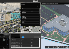
Leading by example, platforms and tools such as ArcGIS by Esri, Trimble Connect, and Hexagon’s Smart Build Insight, to name a few, are shaping effective use and investment into BIM+GIS on the global and Indian fronts. With discussions and knowledge dissemination regarding this fruitful integration now taking centre stage, it is about time authorities and owners of infrastructure projects in the country shift their attention to this need of the hour.