Indian Experience in Alignment with United Nations Integrated Geospatial Information Framework 2nd UN WGIC

Insights into Report: Indian Experience in Alignment with the UN-IGIF

The recently held 2nd United Nations World Geospatial Information Congress (UN-WGIC) in Hyderabad, India, brought together national mapping agencies, Geospatial industries, researchers, academics, and users of Geospatial technology from across the globe. The aim? Promoting comprehensive dialogue on global geospatial information management, its importance, capacities, and capabilities.

During the Inaugural Session of this global event, Hon’ble Union Minister Dr. Jitendra Singh, in the presence of other dignitaries, released the Report on Indian Experience in Alignment with the United Nations Integrated Geospatial Information Framework (UN-IGIF).

Release of Report on Indian Experience in Alignment with the UN IGIF
Release of Report on Indian Experience in Alignment with the UN-IGIF at the 2nd UN-WGIC 2022; Source: Geospatial World

The report provides a brief overview of the types of projects, innovations, and benchmarks established by Indian public and private sector organizations, researchers, and civil society, using Geospatial information, and how these initiatives correspond with the Nine Strategic Pathways of the UN-IGIF.

First, The Basics: What is the UN-IGIF and its Nine Strategic Pathways?

The UN-IGIF was created by the United Nations, in close collaboration with the World Bank, as a foundational manual for creating, integrating, and strengthening Geospatial information management by countries. It seeks to identify areas that need additional input and effort when it comes to establishing geospatial information management procedures.

These are expressed in the IGIF through its Vision and Mission statements, seven Underlying Principles, eight Goals, and nine Strategic Pathways.

IGIF Nine Strategic Pathways
IGIF Nine Strategic Pathways; Source: UN-IGIF Website

The nine Strategic Pathways serve as a general roadmap for achieving sustainable socioeconomic and environmental growth. Spanning three major spheres of influence – governance, technology, and people – the Strategic Pathways are, in a way, the IGIF’s very foundation. The 9 Pathways are presented as parts of a jigsaw puzzle to denote their interconnectivity and true meaning only as a whole.

The 2nd UN-WGIC Report on India’s Alignment with the IGIF: Overview and Key Insights

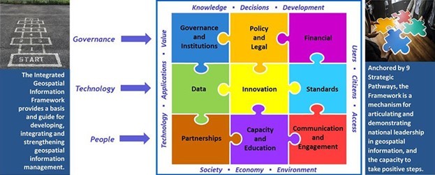
The Report on Indian Experience in Alignment with the United Nations Integrated Geospatial Information Framework has been prepared to present how India’s effective institutional framework is headed for a digital transformation on the shoulders of effective Geospatial information management.

The document examines the systems, processes, and elements of India’s governments, thriving industries, and academic and civil communities that are using, developing, or promoting robust Geospatial information management systems in India.

In doing so, the Report acts as a collection of experiences, called “Examples”, on the path of Geospatial technology and data penetration, data sharing, capacity building, research, and development. On the experiences end is an entire ecosystem of researchers, innovators, and users right from low-level workers to the highest decision-making authorities.  

The example references from the ground have been clustered based on the type of organization that shared the experience of using, managing, and sharing Geospatial information, namely Government, Civil Society, Private, and Academia.

The following sections present a brief insight into some select projects by AGI members published in the Report:

GRAM AWAS: Automatic Weather Alert System for Insurance Companies

Bhugol GIS

Source: Report on Indian Experience in Alignment with the UN IGIF

The project aims to provide meteorological information, localize data, and alert insured customers to take preventive actions with a view to saving precious life and property. Data analysis models were created locally and integrated with the Geospatial data of vulnerable communities. Geospatial maps were then prepared using the GRAM ++ algorithm interfaced with modern real-time communication systems to send out advance alerts and warn vulnerable communities of any expected or anticipated weather phenomenon.

Bhu Kaushal: Empowering India’s Rural Women with Basic to Advanced Skills in Geospatial Technology

Esri India

Source: Report on Indian Experience in Alignment with the UN IGIF

The Bhu-Kaushal, which loosely translates to Geographic Skills, is an Esri India CSR Program for women empowerment designed to impart basic to advanced learning in GIS to empower rural women with spatial skills and the use of GIS technologies. Under the umbrella of women empowerment through the promotion of education and livelihood enhancement projects, the vision of the program is to skill 10,000 rural women in 3 years.

Solving Urban Mobility Challenges in India Using Geospatial Technologies

Google

In its continued efforts to make Google Maps a helpful asset for Government and policymakers, Google is working with local authorities across cities to find scalable solutions for urban mobility issues in India, including traffic congestion, road safety, and carbon emissions. With the help of local authorities across 9+ cities, Google has been able to leverage Geospatial technology to mitigate key mobility issues in a few of the busiest cities in India.

Building India’s Largest Emergency Response System to Transform Public Safety

Hexagon India

Source: Report on Indian Experience in Alignment with the UN IGIF

Uttar Pradesh Police is the largest police force in India and among the largest in the world, with 250,000 officers in 75 districts. A strong need was felt to transform public safety and police response with the help of a reliable, transparent, and coordinated emergency response system for the entire state of Uttar Pradesh. In addition to core call-taking and dispatching capabilities, Hexagon deployed a powerful mobile application with mobile dispatching functions and solutions like patrol management and citizen mobile applications towards this vision.

Removing Institutional Silos in Immunisation Drives using GIS Triangulation

ML Infomap

Source: Report on Indian Experience in Alignment with the UN IGIF

This project was built to provide health officials with digital tools to solve technical and administrative problems arising due to non-comparable immunization data in institutional or program silos. The primary requirement was to create an automated solution to triangulate immunization coverage indicators data and vaccine consumption data that are routinely collected by the government and aggregated every month. The project leverages Geographic Information System (GIS) technology to triangulate such data.

Improving Urban Liveability using Geospatial Technologies for Citizen Services

Scanpoint Geomatics Ltd

Source: Report on Indian Experience in Alignment with the UN IGIF

The Pan-city plan uses smart technological solutions for creating a citywide framework to improve the foundation and administration and make sure that it is accessible to all residents. The broader objectives are to increase the liveability index of the city by using geospatial & remote sensing technologies with visualization techniques, improve citizen services, modernize social infrastructure, and improve cash flows for administrative departments.

GIS-based Visualization for Integrated Highway Maintenance and Construction Planning

Satpalda

Source: Report on Indian Experience in Alignment with the UN IGIF

The power of Geospatial data and visualization for project data integration was leveraged in this project that aims to encourage informed decision-making and integrated planning and maintenance of highway infrastructure in India. The focus was on enhancing communications between different stakeholders, equip decision makers with strategic objectives, accurate asset-related data, as well as planning constraints, and drive data-driven decisions instead of subjective, siloed ones.

Download Your Copy of the Report on Indian Experience in Alignment with the UN-IGIF Today!

Although not an assessment of the IGIF’s implementation in India, the Report has been prepared as a knowledge product for other countries, national and international organizations, and the larger community of geospatial thinkers. These stakeholders can use the document to understand, learn from, imitate, and scale the Indian experience in aligning with the IGIF.