

How the United Nations Geospatial Network is Supporting Global Development Agenda
Some of the biggest challenges to the achievement of the 2030 Agenda for Sustainable Development are geographic in nature. These need to be analysed, modelled and mapped in a geographic context for a global consensus.
This is where Geospatial intelligence, with its impetus for evidence-based and data-driven decision-making, supports development in general and the SDGs in particular. The United Nations Geospatial Network, a coalition of entities within the UN system engaging in Geospatial information management, works towards the same mandate. The network visualises a formal coordination mechanism of Geospatial activities within the UN, and “to serve as a body for global policymaking in the field of Geospatial information management.”
It proposes to fulfil these objectives through the creation of a virtual common platform of resources – the United Nations Geospatial Network Hub. The strategic design and implementation of this Hub encompass seven Transformation pathways and 50 proposed activities.
Geospatial Landscape in the United Nations
Ever since the United Nations adopted the agenda for Sustainable Development in September 2015, Geospatial information has played a significant role in the measurement, implementation and monitoring of SDGs. The mission of the UN Geospatial Network is to boost the coherence and coordination of Geospatial information management within the United Nations, encompassing “overarching trends, technology, practices, data, needs, capacity building, and partnerships.”

Setting up the drone for the documentation of the historic urban fabric of Monsul Old City by UNESCO; Source
The Blueprint document of Geospatial Landscape of the United Nations system goes on to illustrate, “The global Geospatial community can play a critical role in leveraging our understanding of mega-trends and global phenomena through innovative technology, data and analysis.” The United Nations is committed to supporting local, national, regional and global development through a seamless blend of Geospatial mandates and resources across the entire UN ecosystem.
A 2017 survey published in the UN-GGIM report highlights that 33 wide-ranging entities of the United Nations system share Geospatial capabilities, signifying how pervasive Geospatial information is within the United Nations system. These entities collaborate with Official Development Assistance agencies, non-governmental organizations, data providers, public and private organizations, research and academic organizations, and tech companies to expand the tools, methodologies and scope of Geospatial information management across the world.
Various UN Agencies and their Geospatial Mandates
That Geospatial technology can be used for analysing spatial distributions and patterns has accelerated its adoption by the UN for segments as diverse as water & sanitation, healthcare, agriculture, logistics, transportation, real estate, governance, and more. The list of UN agencies using Geospatial data for the advancement of their objectives is exhaustive, spanning several Secretariat divisions, regional commissions, funds, programmes, and even specialized agencies.
The United Nations Statistics Division (UNSD), one of the ten divisions of the Department of Economic and Social Affairs (DESA), acts as the central body for statistical and Geospatial activities within the UN. United Nations Development Programme’s (UNDP) concentrated efforts towards recovery, rehabilitation and reconstruction employ satellite imagery and GIS analysis for improved communication and tracking.
On similar lines, UN-Habitat is trying to address environmental, spatial and socio-economic challenges on an urban level through Geospatial intelligence by extracting land cover & land use data to identifying transport nodes, modelling urban inequalities, locating demographic trends, and more. The intergovernmental Food and Agricultural Organization with 194 member nations use several geo-referenced information systems and databases across divisions.
FAO uses earth observation and thematic data to support sustainable agriculture and mitigate risks. GLC-SHARE is the flagship dataset on the global land cover by FAO that allows easy sharing of geographically referenced thematic information between organizations.
Helping collaborate over and standardize such a broad consensus on Geospatial information is the UN Geospatial Network and the Committee of Experts on Global Geospatial Information Management (UN-GGIM). Established by the Economic and Social Council (ECOSOC) as the apex intergovernmental mechanism for “making joint decisions” on Geospatial information management, the UN-GGIM is the first-of-its-kind global multilateral mechanism for the field.
The Common Denominator: UN Geospatial Network Hub
Through the establishment of a virtual networking hub, the UN is set to create a common repository for supporting various mandates of sustainable development, humanitarian aid, peace, security and more through Geospatial information management. Users, publishers and developers, encompassing the private sector, research institutions, space agencies, societies and academia, along with partners providing Geospatial resources are the various stakeholders of this comprehensive Hub.
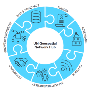
The Context of the UN Geospatial Network Hub; Source
The Hub’s context is structured into three strategic objectives and seven transformation pathways further fragmented into fifty proposed activities. These include:
Strategic Objective I: Building and Strengthening the Network (Governance)
Transformation Pathway 1: Governance
Transformation Pathway 2: Policies
Reports and insights on the Hub would drive efficient governance and mandate regulation for the collection, use, storage and distribution of Geospatial information. Relevant legal affairs can be liaised with, data custodianship established and policies for suitable cooperation mechanism laid out.
Strategic Objective II: Delivering Geospatial information as One (Technology)
Transformation Pathway 3: Data & Standards
Transformation Pathway 4: Innovation & Technology
The UN Geospatial Network Hub will not only help standardize Geospatial data used and shared by Members and users to ensure interoperability but also address legal, semantic, data and technical specificities. Such calibration is to go hand-in-hand with the proliferation of new innovations and scaling up of existing technologies.
Strategic Objective III: Partnerships, Capacity Development and Outreach (People)
Transformation Pathway 5: Partnerships
Transformation Pathway 6: Capacity Development
Transformation Pathway 7: Communication and Outreach
The role of the private sector, academia, international organizations and civic communities has been recognised as a massive resource. However, the absence of a singular entity for geospatial actors within the UN ecosystem has been leading to duplication of costs & efforts, besides inefficient information delivery. The UN Geospatial Network Hub aims to bring into the picture a reinforced sense of cooperation through a coherent model of Partnerships, Capacity Development, Communications & Outreach.
Furthering Dialogue and Engagement on Geospatial-led Global Development
Targeting the development of “One Geospatial Partnership”, the UN Geospatial Network and UN-GGIM are working together to promote uniformity, accessibility and transparency of Geospatial data.
In the face of global challenges such as climate change, unilateralism, and the recent COVID-19 pandemic, effective management and collaboration over Geospatial information through continuous dialogue and engagement can help live up to the UN Geospatial Network’s vision of “Geospatial for a Better World: Transforming the Lives of People, Places and Planet.”

Comments on Post (1)
Pingback : Geospatial AI and Machine Learning to Revolutionize Air Quality Monitoring – AGI India