Geospatial Technologies for Urban Sanitation Planning and Management
Geospatial usage for citizen-centric services has greatly increased as a result of advancements in data collection techniques, the availability of smaller, high-performance sensors, better processing speeds, and a liberalized legal environment. One such area of urban governance that has greatly benefited from Geospatial applications is city sanitation planning.
Sanitation planning and management for a city is a complex procedure that requires huge amounts of constantly available, near-real-time data for effective decision-making. The lack of sanitation infrastructure and improper sewage collection and treatment in developing and undeveloped countries have long exposed citizens to serious health hazards. Rapidly urbanizing and informal settlements with little access to official water and sanitation facilities are the most vulnerable to such threats.
The need of the hour is to improve the delivery of water supply and sanitation services through the development of effective, sustainable, and resilient infrastructure. Geospatial technologies have a key role to play in this regard, providing much-needed spatial and non-spatial data for planning and operations, as well as platforms for managing them.
Key Challenges to Effective Sanitation Planning and Management in Indian Cities
City sanitation plans in India, if any, are typically based on secondary data sources that are way too limited. Data on sanitation and wastewater management is too limited in terms of availability and processing and lacks a thorough understanding of the locational context, topography, and existing infrastructure.
There is also a widespread lack of real-time information updates leading to a dearth of preventive maintenance, damage, and repair. No maps or spatial data are generally available for sewage systems in cities. The same is the case for gradient maps. Such information serves as the cornerstone for the provision of all services at the municipal level and is much needed by local governments to explore innovative solutions, implement micro-level interventions, and close gaps in sanitation facilities for inhabitants.
Tackling Urban Sanitation Challenges with Geospatial Technologies
Geospatial technologies have several benefits to offer for effective sanitation and sewerage management in urban centres. They can be used as a smart planning tool to come up with successful plans, map settlements lacking domestic sanitation, investigate existing drainage networks, and quantify access to water and sanitation services within the city’s authority.
Additionally, GIS-based platforms may be accessed and analyzed via cloud solutions regardless of place or device. This makes data representation easier and makes it easier to spot sanitation service delivery gaps.
GIS systems can run complex queries to determine whether all houses on a map are numbered, measure proximity to water supply and drainage, identify the occupancy of the structures, identify the location of waste collection, etc. This is achieved by layering information on several features, such as sewer access locations, gutter lines, garbage bins, roads, water stand posts, taps, and community toilet blocks, along with household-level data.
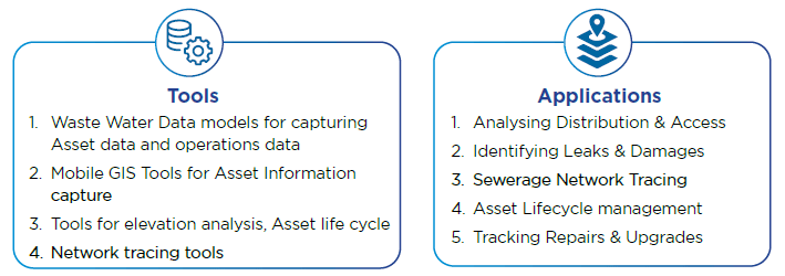
Wastewater managers can identify the occurrence and location of leaks through physical assessments performed by drones equipped with sensors. To prioritize ongoing system maintenance, city managers can use historical GIS data. This can assist engineers in making more cost-effective decisions when addressing problematic leaks and executing repairs and improvements.
A mathematical model called hydraulic modeling is used to determine the hydraulic properties (flow) of water into and out of a sewer system. GIS integration has made it possible for wastewater utilities to maintain system components like pipelines, valves, and storage tanks.
GIS databases can be used to record the dates of pipeline installation, confirm the diameter, and identify upcoming changes to system operations in the network that may be brought on by increased demand. Engineers may then see in detail how modifications to the network may impact the volume of flow (hydraulics) from a wastewater plant and across a sewage system by plugging this information into the hydraulic model.
Additionally, managers and engineers can access a graphic interface of the sewer and wastewater infrastructure’s characteristics using GIS to determine its kind, age, and condition. These programs can be used to keep track of upgrades and repairs and install new infrastructure, and the data can be captured and saved in a GIS database for quick access at any time.
Case in Point: Swachh Bharat Mission
India’s flagship sanitation programme, the Swachh Bharat Mission (SBM) has been designed in two phases: Phase 1 lasted till October 2019, while Phase 2 is being implemented between 2020–21 and 2024–25 to help cement the work of Phase 1. The mission initially aimed to achieve an “open-defecation-free” (ODF) India by 2 October 2019 through the widespread construction of toilets. The second phase of the mission aims to sustain the open defecation-free status and improve the management of solid and liquid waste, while also working to improve the lives of sanitation workers.
Under the programme, Bharat Maps, a multi-scale, multi-resolution, multi-layer GIS platform was built on a service-oriented framework by the National Informatics Centre (NIC). The platform integrates API-based OGC-compliant map services with e-Governance workflows associated with the SBM.

The Bharat Maps project by NIC MeitY was honoured with the Award for Excellence in Mapping for Development at the India Geospatial Leadership Summit (IGLS 2022)
Self-attested geo-tagged photographs of the construction and the applicant are used to verify constructed household toilets. All photographs are uploaded to the SBM (Urban) Management Information System (MIS) and monitored by Urban Local Bodies (ULBs) and States. A Swachh Survekshan survey integrated entirely with GIS is routinely carried out with two distinct components of data collection for monitoring the complete progress of projects.
The Ministry of Housing and Urban Affairs (MoHUA) has partnered with AGI member Google to map all public/community toilets on Google Maps, and unique IDs have been allotted to them for easier management. MoHUA has also launched a compendium and dynamic GIS portal showcasing innovative practices for effective solid waste management (SWM) practices from across India.
The Takeaway
In the last few years, a large number of Indian cities have embraced Geospatial technologies to transform their municipal operations. Not just the Central, but even State and Local Governments are using cutting-edge Geospatial tools and data to address problems with sanitation planning and administration in their respective areas.
Recognizing the advantages and difficulties of using Geospatial technology for city-wide applications is urgently needed, and responsible solutions must be sought. One of the issues with this vision is the vast technical skill gap between city officials and Geospatial technologies.
To make the best services, solutions, platform development, and analytics on a case-by-case basis, we are going to need qualified resources at all levels and a deeper level of collaboration from geospatial private sector professionals. Public-private partnerships can provide citizen-centric platforms with equal liability and obligation, and an integrative strategy can be used to hasten the adoption and advantages of Geospatial technologies for citywide sanitation planning and management.