

Future of Location and Business Intelligence: Where Are We Heading?
We live in the age of analytics. Businesses are aiming for more data-driven decisions by incorporating analytics, visualization and infrastructure. The idea is to eliminate inefficiencies throughout, which can only happen when you have a comprehensive view of data, in and out.
As a result, businesses are collecting data at every level, and in unprecedented volumes. Interestingly, more than 80% of the data amassed by organizations has a spatial element to it.
Clearly, the need to map, visualize and understand data from a geographic standpoint is now more important for businesses than ever. Data analytics in general, and location intelligence in particular, are critical navigational tools that businesses must equip themselves with. And top businesses around the world are already warming up to it.
Location and BI: Potential, Outcomes, Examples
The COVID-19 pandemic has cemented the role of the Fourth Industrial Revolution, the era where the lines between physical, digital, and biological worlds are blurred. Businesses have been facing the unprecedented impact too, finding themselves in a sudden need to go digital. Location Intelligence can offer such businesses strategic and tactical advantages.
Location Intelligence for Businesses; Source: Location Intelligence Market Report 2019, Geospatial World
Customer Experience: Consumer behavior can be anticipated using geospatial tools in coalition with AI workflows. Key insights like average age of customers, store visit patterns, preference to public or private transportation, hourly and daily footfall, for instance, can help companies tailor products, services, and schedules for improved outcomes.
Marketing Intelligence: Businesses can factor in visibility and access when deciding where to site their store and how to promote it. They can also customize regional advertising, content, and promotions based on regional demographics Targeted audience campaigns can be sent to customers in the vicinity of businesses, based on their real-time location and location history.
Inventory and Delivery Management: Advanced routing to determine the most efficient path for multiple deliveries can be designed, based on real-time route conditions, along with smart, unmanned vehicles or robots for delivering goods.
Take global mobilities disruptor Uber, for example. The Uber app takes and matches the location of users with the closest driver, besides guiding the later to the chosen destination. The entire process draws from the application’s geospatial data. Not just this, Uber also uses location intelligence to determine areas with the highest demand for drivers at specific hours of the day, thereby advising active drivers to be near those hotspots during those very hours.
American fast-food giant Wendy’s carefully researches location using mapping software as well as demographic information, like population, households, average income, and nearby businesses to determine the right site. Global engineering and construction firm CDM Smith Inc uses geospatial data for creating plans, layouts, and maps for design and engineering.
Industries and Value Propositions
A blend of internal business data and external location data, overlayed with metrics and indicators can facilitate greater operational efficiency and wider scope for businesses across industries. For instance:
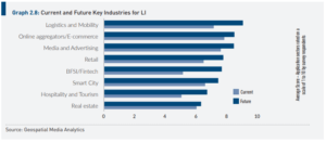
Current Future Industries Location & BI; Source: Location Intelligence Market Report 2019, Geospatial World
Agriculture companies can use Geospatial Business Intelligence to improve production planning by factoring in crop, land, irrigation and weather/climate data. Produce can be tracked with precision with respect to batch numbers, storage conditions, and location in the supply chain.
BFSI organizations can segment clients and users based on their location to create more effective marketing and sales strategies. Targeted online campaigns can be generated for reliable customer support, as well as for smoothening application, financing, and delivery procedures.
Healthcare organizations can leverage maps for plotting areas with high concentrations of patients or high health hazard indicators for rendering services. Hospitals, clinics, pharmacies, and primary healthcare units can be charted to offer routing guidance.
Insurance companies can use location intelligence to analyze and categorize disaster-prone, populous, underserved, high claim, and high false claim areas distinctively for strategies, pricing, and policies. Insurance premiums can be increased for disaster-prone areas. Farms expected to yield certain output are given premiums based on their location. Geospatial intelligence together with AI and ML can be used to offer risk prevention support to customers, as well as for address verification.
Real Estate ventures can use spatial analytics for research, analysis, and presentation of each prospective site for further development, as well as for real estate valuation. Houses located in disaster prone areas or away from facilities are valued less than those in safer locations and around facilities like schools, clubs, hospitals etc.
Retail businesses can monitor stock distribution, product sales, as well as customer interactions and behavior from region to region, shop to shop for effective decision-making. Targeted marketing campaigns based on customer location data can be harnessed to personalize experiences, while more visibility can be gained into the supply chain, right from organizing and packing to final delivery of products.
Telecommunication sector can use geospatial data for route optimization, infrastructure assessment, competitor network coverage analysis, and so on. Geospatial analysis together with predictive analytics can even help determine future wireless use hotspots accurately, for instance.
Transportation companies can use geospatial tools and technologies, such as IoT sensors, automated drones and GPS, for regular monitoring of routes, tracks, tunnels, and so on, eliminating the need for often unsatisfactory manual surveys. Real-time position of vehicles can be mapped, besides passenger hotspots for directing services.
Utilities companies like water, rail, gas, and power can use geospatial intelligence in combination with predictive analytics to optimize monitoring, detecting problems, determining further actions, scheduling, and tracking operations on visual dashboards. Location intelligence can make it easier for them to determine areas with higher demands or issues as well.
The Future of Geospatial Business Intelligence is in the Four A’s
Combining location or geospatial data, analysis, and visualization with business intelligence is all set to see much heightened interest in the days to come. This brings us to the four imperatives that Location and Business Intelligence would be heading for.
Architecture: Only the right technology system architecture can help companies gather relevant information and process it suitably for use. Along with choosing the best out on-premises, cloud, or hybrid systems, businesses must also focus on up-and-coming trends in connectivity like 5G to stay capable and powerful.
Analytics: The collected Geospatial data can be structured or unstructured, static or dynamic, and from an array of sources like drones, satellites, GNSS, LiDAR, and so on. It can be enriched by the addition of crowdsourced data as well as social media analytics in the near future. However, all such information must be embedded within a context, extracted, combined, and analyzed to produce usable information.
Artificial Intelligence: Clearly a major player in the advancement of Geospatial Business Intelligence, AI will help automate decision-making by modelling several business aspects.
Automation: The interest in autonomous products and services is already on the rise, with Geospatial data being used to build high-definition 3D maps vital to autonomous applications. The future will see further collaboration among humans, machines, and geospatial intelligence for the purpose.
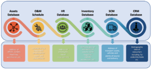
The growing adoption of new technologies like Artificial Intelligence (AI), Augmented/Virtual Reality (ARVR), Cloud Computing, Internet of Things (IoT), along with advancements like 5G on the horizon are truly cementing LI improvement and applicability. Businesses can use geospatial business intelligence today for not just rendering basic features like map-based visualization, but also enabling complex analytics across Assets, HR, Inventory, SCM and Inventory databases as well as O&M schedules.
The future holds more power and more dimensions for the confluence of location and BI. Linkages between geospatial data, advanced technologies, spatial analysis, crowdsourcing, as well as social media are set to drive new models and outcomes.

