Comprehensive Enterprise Application for Ajman Municipality using BIM and GIS
Digitalization is currently driving the entire society. It is manifesting itself in many process-oriented fields, including urban planning, building permission, and emergency management processes, characterized by a high number of involved stakeholders, both from the industry and authority side. In order to increase efficiency of these processes, it is necessary to digitally integrate information, both between stakeholders and between processes.
The building permission process is, to a large extent, a continuous process where much information is still handled in paper format or as independent CAD/PDF files. With digitalization comes the potential to automate the submission, validation, and permit processes by adopting / integrating Building Information Models (BIM) of planned buildings and geospatial technology – allowing a 3D visualization of the building, and thus making it easier to check if the building complies to building permission regulations and city master plan requirements.
Case Study: Building Permit Department of The Ajman Municipality, UAE
Many entities are still struggling with a manual, long, and inefficient building permission process. The Building Permit department of the Ajman municipality in the United Arab Emirates particularly faced issues in terms of receiving building plan drawings in the form of 2D CAD drawings, which did not facilitate the municipality to visualize building elements in a 3D environment or easily validate plans against building standards. In addition, the 2D CAD drawings also complicated the execution of standard building data analytics based on certain defined criteria.
Avineon partnered with Ajman Municipality as a consultant to study their existing processes, investigate the CAD templates currently in use, and perform a gap analysis with respect to Building Information Model (BIM) standards and readiness to adopt – all in effort to build an enterprise application that enables:
- converting 2D CAD files to BIM
- converting BIM to GIS
- develop an interactive BIM viewer application.
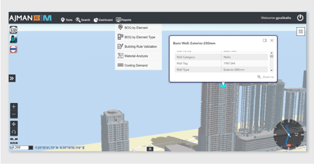
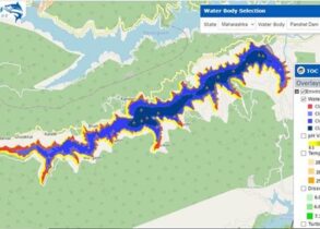
Figure 1: GeoBIM enabling Digitalization for the Ajman Municipality; Source: Avineon
Aim and Objectives
The municipality wanted to reap the benefits of an enterprise geo-enabled, BIM-based, 3D building model, that can virtualize a building, starting with the geo-location of the building, over to the validation of building code guidelines for CAD/BIM drawings, and also including the execution of analytics across buildings and regions.
In addition, the municipality wanted to convert existing buildings from archived CAD drawings to a geo-enabled BIM environment to enable a seamless view and analysis.
Scope and Outcomes: An Interactive BIM Viewer Application
- The development of BIM data standards, specifications, and a GeoBIM data model
- The development of a CAD template, standards, and specifications to be adopted for future CAD drawings submissions by consultants, developers, and designers
- The development of tools to convert 2D CAD floor plans to BIM, and convert BIM to GIS
- The conversion of close to 15,000 legacy building floor plans from paper/CAD to BIM
- The re-engineering of the business process for design review by the municipality. This was done by generating a Revit model from CAD, by using automated tools, and the loading of this model into the 3D GIS application
- The development of a 3D GIS application for viewing and analyzing BIM models along with query, search, filter, and analytical tools. In addition, this 3D GIS application was integrated with the existing GIS systems and database
- While providing consultancy to the municipality, Avineon also focused on developing System Architecture and IT infrastructure sizing to enable system performance.
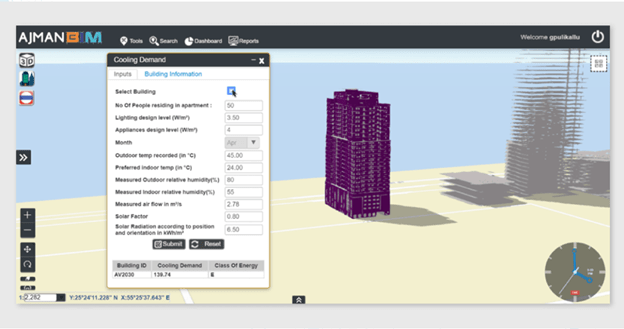
Figure 2: The Geo-enabled Ajman BIM Platform; Source: Avineon
Avineon also focused on developing applications on Design & System Architecture through customized BIM viewer tool, 3D WebGIS application with query, search, filter, analytical tools and also developed tools for automated conversion from CAD to Revit model and loading of Revit model to 3D GIS app. The digitization of building permit process not only set standard templates & specifications to enable multiple stakeholders to submit building designs in BIM upto LOD 500 but enabled to visualize buildings in BIM before approving designs.
This simplified the business processes by bringing in efficiency through digitization and enabled the municipality with a 3D view of the buildings to easily validate plans against building standards.